Exeter, UK, July 20, 2026 (GLOBE NEWSWIRE) — Dronedesk, the drone fleet management platform used by more than 840 organisations worldwide, today announced a fully integrated Specific Operations Risk Assessment (SORA) capability, supporting both the UK SORA framework and the EASA JARUS SORA 2.5 methodology.

BVLOS pipeline inspection over remote terrain, a signature use case for Specific category drone operations.
SORA is the gateway to the Specific category, and to the beyond visual line of sight (BVLOS) operations that underpin most commercial drone growth, from infrastructure inspection to survey, mapping and delivery. Yet building a SORA has remained slow, specialist work, and the population density assessment at its core has been one of the biggest bottlenecks. Dronedesk removes that friction.
Believed to be the first implementation of its kind on the market, the new capability integrates the complete SORA calculation directly into the Dronedesk flight planning workflow and fully automates the population density assessment that drives every ground risk determination. Work that previously demanded hours of specialist GIS effort is now completed in seconds.
Both frameworks, UK SORA and EASA JARUS SORA 2.5, are fully implemented and available in-product now.
The barrier to BVLOS
For most operators, the barrier to BVLOS has rarely been technical capability. It has been the approval. Specific category drone operations now rest on a defensible SORA, and the population density calculation, how many people are exposed beneath the operation, is where much of the time, cost and risk of error has sat.
By automating that calculation and building the whole assessment into planning, Dronedesk shortens the path from concept to authorised operation. An operator can model a route, see the population density, ground and air risk and resulting SAIL immediately, and iterate the geometry until the operation is viable, all before a single form is submitted.
Solving the population density problem
Establishing the maximum population density beneath a planned operation is one of the most time-consuming and error-prone parts of a SORA. Operators typically have to rely on manual GIS analysis, exported map data and consultancy time to answer a single question: how many people are underneath the drone?
Dronedesk automates this end to end. Drawing on the Copernicus Global Human Settlement Layer (GHS-POP), the platform evaluates population density across the realistic dispersion area of the aircraft at its declared operating altitude, using the sliding-window kernel method defined in JARUS Annex F. It fetches the population data on demand, computes density across every cell within the operational zone, and produces a per-cell audit trail that can be exported for independent review. The result is a defensible, traceable figure produced in seconds rather than hours.
Because the calculation lives inside the flight planning workflow rather than in a separate tool or spreadsheet, the risk picture updates automatically whenever the operational geometry changes. From the flight geography, Dronedesk derives the contingency volume, ground risk buffer and adjacent area, determines the intrinsic Ground Risk Class, supports the selection of ground risk mitigations, classifies the Air Risk Class using live airspace data, and produces the final SAIL, all within a single, self-contained report.
Built in consultation with the UK CAA
The UK SORA implementation was developed in direct consultation with the UK Civil Aviation Authority, with key methodology decisions, including the population density approach, discussed with the CAA’s SORA assessment team. Dronedesk’s population density methodology has been reviewed by the CAA’s assessment panel and acknowledged as a correct interpretation of the JARUS SORA Annex F methodology (section 3.9.1, map resolution as a function of intended operating altitude). This acknowledgment applies to the methodology; each application is still assessed on its own evidence.
For operators, this removes a common source of uncertainty. Rather than defending a bespoke population density calculation from scratch, they apply a method already reviewed against the published JARUS guidance. Dronedesk reinforces this by prompting operators in-app at exactly the points where a National Aviation Authority (NAA) will expect written justification, capturing that reasoning as the assessment is built and helping to smooth approval timelines.
The capability has already been used in a live regulatory context, supporting a successful application to establish a UK drone Test and Evaluation site.
Quote from Dorian Ellis, Founder and Director of Dronedesk
“SORA is the single biggest hurdle standing between operators and the BVLOS approvals that unlock real commercial drone work, and the population density calculation is the part that eats the most time and creates the most risk of getting it wrong. We have taken that entire process, the geometry, the density modelling, the risk classification, and built it directly into the flight planning workflow. What used to take hours, or a specialist consultant, now takes seconds, with a complete audit trail the assessor can follow line by line. As far as we are aware, no other platform has fully automated this and integrated it into planning. For anyone trying to scale BVLOS operations, that is a real step change.”
Industry reaction
“In my opinion, Dronedesk is the best tool for managing the RAMS and SORA element. I will be recommending it to anyone who doesn’t use it.”
Elliott Corke, Director, CAJE Systems (cajesystems.co.uk)
Availability
The UK SORA and EASA JARUS SORA 2.5 capabilities are live now, available as a paid add-on on Dronedesk’s Pro tier and above. Full methodology documentation is available at:
- UK SORA: https://dronedesk.io/dronedesk-uk-sora-methodology
- EASA JARUS SORA 2.5: https://dronedesk.io/dronedesk-jarus-sora-2-5-methodology
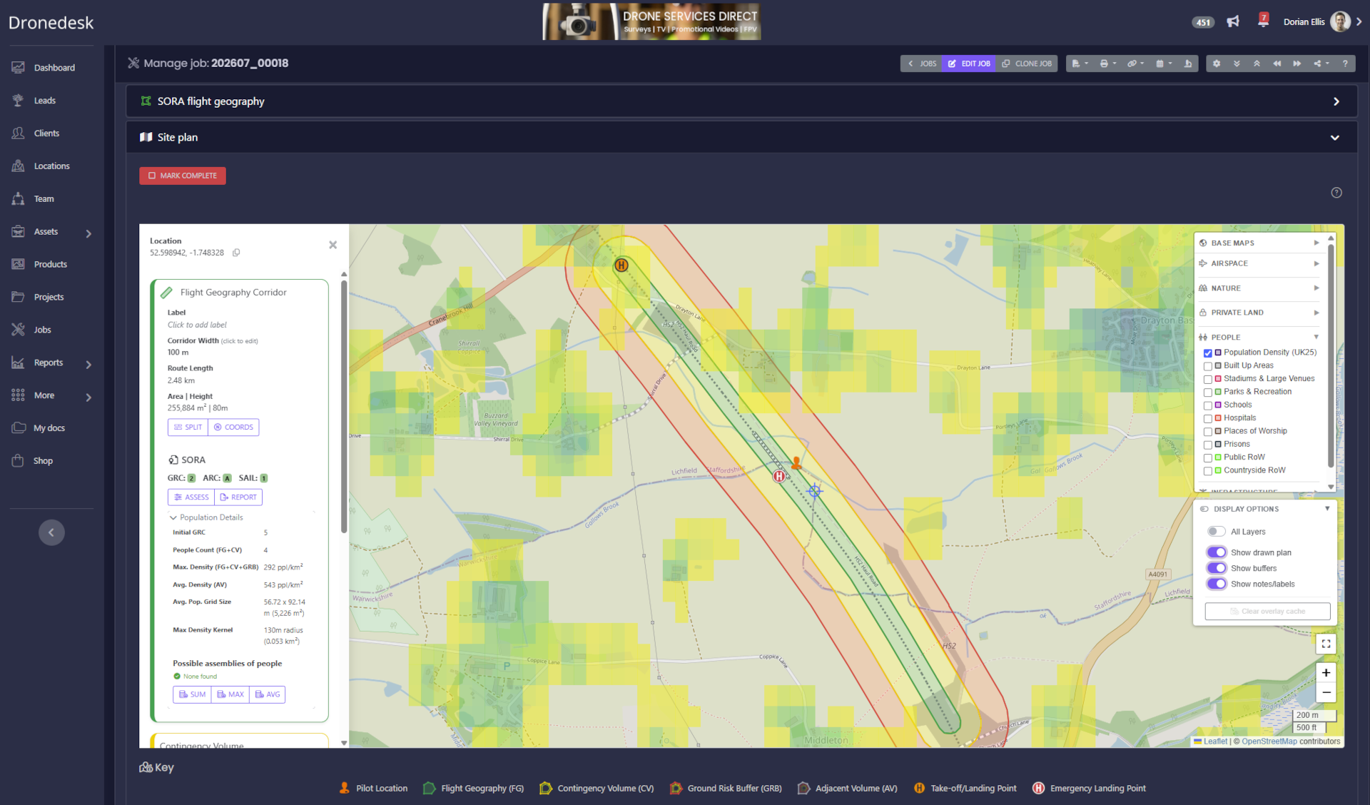
A Dronedesk site plan showing the flight geography, contingency volume and ground risk buffer over the population density overlay.
About Dronedesk
Dronedesk is a drone fleet management platform which helps any company that uses drones to manage their drone operations faster, safer and more compliantly. It enables companies to ditch the spreadsheets and document templates and to dramatically increase their operational efficiency, improve oversight and reduce risk by providing a single platform to manage every aspect of their drone operations. Established in 2019, Dronedesk is used by over 840 organisations and more than 2,500 pilots across North America, the United Kingdom and Europe, and it is the number one user-rated application of its type. Learn more at dronedesk.io
Press Inquiries
Dorian Ellis
press [at] dronedesk.com
+443300439373
https://dronedesk.io
A video accompanying this announcement is available here: https://youtube.com/watch?v=MIgHTMjQQuU